Explore our natural assets
Nature… it’s like our secret battery charger! Whether you’re into gardening, walking, paddling, riding, picnicking, birdwatching, playing at a local park or just relaxing in the great outdoors, there’s something for everyone.
There are a range of local nature hotspots that are near and dear to our hearts. Here’s a sample of some of our unique natural assets.
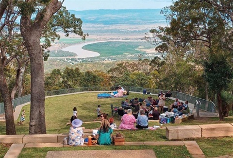
Fraser Park, Mount Archer
Located at the Summit of Mount Archer, Fraser Park is an iconic destination for locals and visitors. The site is specially zoned for environment and conservation use and best known for its walking trails, picnic spots and views of Rockhampton and surrounding areas.
As the gateway to Mount Archer National Park, Fraser Park provides a setting in which to protect, celebrate and connect with culture and our environment. Take in breathtaking views of the region as you watch the sunrise and enjoy an early morning walk with the birds or share a picnic as you watch the sunset over Rockhampton.
To visit Fraser Park, Mount Archer head up Frenchville Road and turn onto Pilbeam Drive. Fraser Park features many walking tracks, amphitheatre, playground, tables and chairs, and incredible views of the Region from the Nurim circuit elevated boardwalk.
The Fitzroy River and associated waterways and wetlands
The Fitzroy River is the region’s major waterway and the largest river catchment flowing to the east coast of Australia. As a key natural asset, the river delta and flood plain are considered to be nationally important wetlands. The river is mapped as a Fish Habitat Area and the delta also hosts one of three known populations of the critically endangered Capricorn yellow chat. The Fitzroy River drains to the Great Barrier Reef lagoon. The Region’s lagoons each have their own individual character and attract a myriad of bird life, which is great for birdwatching or just enjoying a walk in the great outdoors. Head on down to the Riverside Park to enjoy some river views or get out and about to explore everything the river has to offer.
Find out more about the Fitzroy River in this map journal prepared by Queensland Government.
Mount Morgan, Number 7 Dam
Visit the 'Big Dam' at Mount Morgan and enjoy a swim, take a kayak or enjoy the huge shady playground. Take some time out to enjoy a walk, a swim or a paddle or take in some of the local bird life. You can also enjoy the huge shady playground, take a picnic or fire up the free electric BBQs.
To visit Mount Morgan Number 7 Dam head along Byrnes Parade. This site has a covered playground, BBQ's, amenities block and shaded table and chairs.
First Turkey, Mount Archer
Head into First Turkey and get away from it all, just minutes from suburbia.
Council manages 188 hectares of reserve and freehold land, adjacent to the Mount Archer National Park. Enjoy over 20 kilometres of mountain bike tracks cradled between Moores Creek and Mount Archer National Park. The tracks cater for a range of novice and experienced riders. Map available. Or take a short walk to explore some popular walking tracks and swimming holes along Moores Creek. The swimming hole is best after decent rainfall, once the creek has stopped rushing.
You’ll also find an outdoor learning facility, a composting toilet and wayfinding signage nestled within First Turkey.
To visit First Turkey, the start of the trails can be entered via German Street, Norman Gardens.
Springers Lagoon
Our Region includes extensive wetlands, creeks and river systems covering nearly 6% of our total area. Renowned for a wide variety of local birdlife, Springers Lagoon is a popular site for swimming, fishing, kayaking, bird watching and picnics. It also serves as a designated water reserve for travelling stock.
Springers Lagoon is recognised as being a Matter of State Environmental Significance (MSES) for biodiversity and wetland values (this includes the waterway plus a 100 m buffer). It is situated on Teatree Creek, which flows across the Fitzroy River floodplain to join Scrubby Creek, then Frogmore Lagoon and finally Gavial Creek. It is a critical link in the chain of wetland habitats that extend from the estuarine reaches of the Fitzroy River to high value upstream wetlands.
To visit Springers Lagoon, head out to Gracemere, turn onto Sullivan's Road and follow along until you find this hidden beauty.
Murray Lagoon
Murray Lagoon is a picturesque backdrop to Rockhampton Botanic Gardens. Capture the stunning afternoon sun sets, spot an array of birds, turtles and fish from the viewing platform or use the BBQ facilities when you visit.
To visit Murray Lagoon, access either via the Rockhampton Botanic Gardens or use the walking path from Blackall Street, South Rockhampton.
Bouldercombe Gorge and Falls
Take a walk through Bouldercombe Gorge Regional Park.
Situated behind Bouldercombe between Rockhampton and Mount Morgan, the gorge cuts into the Razorback Range and Crocodile Creek runs along the gorge floor. After good rain, a system of creeks, waterfalls and waterholes are present, providing a welcome refuge for wildlife. Bouldercombe Falls provides a popular local swimming hole.
Queensland Parks and Wildlife Service manages the 3970ha area to protect its significant natural values. Bouldercombe Gorge Regional Park protects eight different regional ecosystems and a number of significant species including the black-breasted button-quail (Turnix melanogaster), scarlet fuschia (Graptophyllum excelsum), Cycas megacarpa and Decaspermum struckoilicum.
The area caters for a low level of self-sufficient visitors. Caution should be taken as there are unformed tracks and the area can be subject to flash flooding. Visitors should take extra care during the wet season and rainy weather and remember to never cross flooded creeks.
To visit Bouldercombe Gorge, head 20km south of Rockhampton. The north section (with formal walking track) is accessible via Mount Usher Road and the middle section via Struck Oil Road.
Limestone Creek Conservation Park
On Rockhampton’s northern outskirts lies the little known Limestone Creek Conservation Park. Featuring a network of walking tracks through open eucalypt woodland, this park offers a quiet respite from the noisy city. A great location for morning and afternoon walks, all tracks are level and an easy grade, so get a group together and explore.
To visit Limestone Creek Conservation Park, head to the corner of Norman Road and Yeppoon Road and access walking tracks via the entry, west of the QPWS office.
Goodedulla National Park
Goodedulla meaning 'flying eagle' in Durumbal language, is a remote National Park about 50km north of Gogango.This remote park of picturesque meandering semi-permanent creeks within hilly to mountainous areas is ideal for birdwatching. Covering 26,025ha, Goodedulla National Park conserves the only land zone of granites, acid volcanics and Permian sediments within the central Brigalow Belt. Park vegetation is diverse and includes rosewood and vine forest.
To visit Goodedulla National Park by turning off the Capricorn Highway at Gogango and follow the signs north to Rookwood Station. Access to this Park is unsealed and traverses private property. It is accessible by four-wheel drive only and you must be self-sufficient.
Yeppen Lagoon
Located to the left as you enter Rockhampton via the Capricorn and Bruce Highways, Yeppen Lagoon provides a beautiful first impression of our Region. A good spot for walking, riding scooters or bikes follow the path along the banks of Yeppen Lagoon between the parking area at Blackall Street and Rockhampton Botanic Gardens.
To visit Yeppen Lagoon, head to the parking area off Blackall Street, Rockhampton.