South Rockhampton Flood Levee
Announcement
Council continues to seek funding for this project.
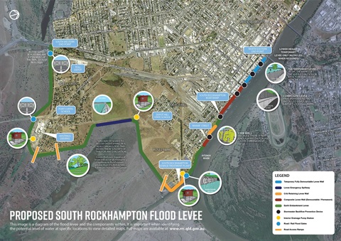
This major infrastructure project involves constructing an approximately 8.74km flood levee that extends from the Fitzroy Bridge in Rockhampton CBD to the Bruce Highway (at the intersection with Jellicoe Street) via Quay Street, Wharf Street, Fiddes Street and Jellicoe Street, in the localities of Depot Hill and Port Curtis.
The proposed SRFL is designed to prevent the Fitzroy River flooding parts of Rockhampton’s Central Business District (CBD), Port Curtis and Depot Hill areas during major flood events up to a 1 percent (%) Average Exceedance Probability (AEP) or provide 100 year Average Recurrence Interval (ARI) flood immunity. This will be equivalent to a 9.89m flood gauge level post SRFL construction.
Following Planning approval by State Government detailed design and documentation has been completed. Council continues to seek the additional funding required to complete this project.
The EAR is included in the following links:
Part A - Environmental Assessment Report(PDF, 10MB) (PDF, 37MB)
Part B - Assessment of Matters(PDF, 37MB)
Part C - Appendices
Appendix A - Project Area(PDF, 62MB)
Appendix B - List of Stakeholders(PDF, 245KB)
Appendix C - Summary of Consultation Activities(PDF, 2MB)
Appendix D - Early Works Consultation Report(PDF, 773KB)
Appendix E - Concept Design Plans(PDF, 90MB)
Appendix F - Concept Design Report(PDF, 98MB)
Appendix G - Geotechnical Design Report(PDF, 256MB)
Appendix H - 2019 Fitzroy River Baseline Model Update Report(PDF, 12MB)
Appendix I - South Rockhampton Local Catchment Baseline Flood Study(PDF, 101MB)
Appendix J - Hydraulic Assessment Report Volume 1 and 2(PDF, 190MB)
Appendix J - Updated Vol-1 Hydraulic Assessment Report(PDF, 16MB)
Appendix K - Interior Drainage Report Volume 1 and 2(PDF, 94MB)
Appendix L - Failure Analysis Report(PDF, 39MB)
Appendix M - Operations and Maintenance Manual(PDF, 2MB)
Appendix N - Emergency Response Plan(PDF, 2MB)
Appendix O - Vulnerability and Tolerability Report(PDF, 13MB)
Appendix P - Wetland Assessment Report(PDF, 5MB)
Appendix Q - Ecological Assessment(PDF, 6MB)
Appendix R - 2014 Heritage Report(PDF, 2MB)
Appendix S - Economic Assessment Report(PDF, 1MB)
Appendix T - Environmental Management Plan (Planning)(PDF, 827KB)
Appendix U - MID Cross Reference(PDF, 269KB)